Cloughmore & Rostrevor
A forty-tonne granite boulder sitting high above Carlingford Lough, left there by a glacier and claimed by a giant. Four kilometres round from Kilbroney Park, up through the oakwood and back down a different path, with the Republic laid out across the water.
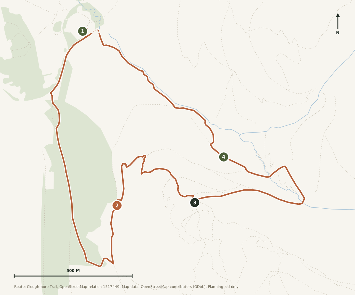
Waymarked as a clockwise loop, so you come down a different path from the one you went up. The distance here is measured from the mapped route, not from the signpost.
The forest swallows the signal in places. Save a copy before you leave and you will still have the route and the parking when your phone gives up.
The biggest view for the least effort
If Donard is the walk people talk themselves into, this is the one they actually do twice. Four kilometres, under 300 metres of climbing, forest track and clear path the whole way, and it is waymarked as a loop so you cannot really go wrong in daylight. An afternoon is plenty.
What you get at the top is out of all proportion to the effort. The stone sits on an open shoulder with Carlingford Lough directly below, the Cooley Mountains across the water in the Republic, and on a clear day the whole sweep down to the Irish Sea. It is the view that sells the Mournes to people who did not think they liked hills.
Go late. The stone faces west down the lough, so the light at the end of the day is the whole point, and the car park empties out after four.
The route, stage by stage
A clockwise loop from Kilbroney Park: up through the oakwood on forest tracks, a short steep pull to the stone, then a longer, gentler descent back through the trees by Fiddler's Green.
Distances are cumulative from the car park. Follow the waymarkers clockwise; going the other way makes the climb steeper and the descent harder on the knees.
Up through the oakwood
From the car park by the Cloughmore Centre, pick up the waymarkers and climb steadily on a broad forest track through Rostrevor's oakwood. This is old sessile oak, one of the last decent stands left in the north, and in early summer the whole hillside is loud with birds. The gradient here is honest but never unkind.
The pull to the shoulder
The trees thin and the track narrows to a path for the only properly steep section of the day. It is short, it is stony underfoot, and it is where you will stop to take your jacket off. Keep going: the ground levels out onto open shoulder almost as suddenly as it steepened.
The stone
And there it is: a granite boulder the size of a small van, sitting on an open slope with nothing behind it but sky and water. Carlingford Lough runs away below you, the Cooley Mountains rise on the far side in the Republic, and the whole thing opens out to the Irish Sea. There are benches. Use them.
Worth knowing: the ground beyond the stone drops away steeply on the lough side. It is a fine place to sit and a poor place to wander about in the dark or with a dog off the lead.
Down by Fiddler's Green
The loop turns back into the forest and drops at a much friendlier angle than it climbed, swinging round through the trees and back down to the park. It is longer than the way up and easier on everything. You will be back at the car before you have finished talking about the view.
The route on the map
Open the printable route map →The waymarked Cloughmore Trail as mapped in OpenStreetMap, 4.1 km round from Kilbroney Park. Use the layer control for terrain and contours. A phone map is not a substitute for OSNI Sheet 29.
The climb, in profile
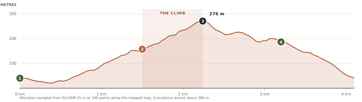
The shaded band is the one steep section. Everything either side of it is a forest track, which is why this walk feels much easier than the numbers suggest.
Forty minutes around the coast
South through Kilkeel, then west along the shore of Carlingford Lough through Greencastle and Killowen into Rostrevor. Kilbroney Park is signed from the village; follow the park road up past the caravan site to the top car parks.
Parking
Free, in Kilbroney Park. Several car parks; the one by the Cloughmore Centre puts you closest to the start of the trail. Busy on summer weekends, quiet on a weekday evening.
Facilities
Toilets, a cafe in the park, a playground and a caravan site. This is a proper park, not a lay-by, which makes it an easy one to bring people to.
Dogs
Welcome on leads. Note the park also carries mountain bike trails, so keep dogs and small children close where the routes cross.
Public transport
Rostrevor is served by Translink buses from Newry and Kilkeel, but the connections from this side of the mountains are slow. This is the one walk of the five we would tell you to drive to. Check Translink if you would rather not.
The park road climbs past several car parks. Keep going to the upper ones near the Cloughmore Centre unless they are full.
Less than you think
Always
Shoes with grip. Trainers are fine in dry weather; the steep section is stony and slick after rain.
A layer more than you set off in. The shoulder is open and the wind comes straight up the lough.
Water. There is a cafe at the bottom and nothing at all above it.
A head torch if you are going up for the sunset, which you should.
Worth it
Binoculars. You can pick out the villages on the Cooley side.
Something to sit on. The benches are usually taken by the time the light is good.
Money for the cafe at the bottom, which is the correct way to finish this one.
An easy walk, with two things to watch
This is a forest walk on waymarked paths and it is genuinely hard to get lost on it in daylight. It does not need the planning that Donard does. Two things still catch people out.
The ground beyond the stone. The slope on the lough side is steeper than it looks from the bench. Keep children and dogs on the path side of the boulder.
The light going. Under the trees it gets dark a good half hour before it does out on the open hill. If you climb for the sunset, take a torch for the descent.
Bikes. Kilbroney is a serious mountain biking centre. Where a walking path crosses a bike trail, look before you step out.
In an emergency: dial 999 or 112, ask for Police, then Mountain Rescue. Mourne Mountain Rescue Team cover this side of the range too.
Dropped by a glacier, claimed by a giant
The dull answer is that Cloughmore is a glacial erratic: a lump of granite carried here by ice during the last glaciation and left sitting on the hillside when the ice melted away. It weighs something in the order of forty tonnes and it is resting, not rooted, which is exactly why it looks so wrong where it sits.
The better answer, and the one you will be told locally, is that Finn McCool threw it. Depending on who is telling it he was aiming at a rival giant across the water in the Cooleys, and depending on how the evening is going he either hit him or missed. The name simply means the big stone.
Both stories are worth having. One explains the geology and the other explains why people have been walking up here to look at a rock for a very long time.
One of the last old oakwoods in the north
The first part of the climb goes through Rostrevor's oakwood, a surviving stand of native sessile oak on a steep slope above the lough. Most of Ireland's oak cover went centuries ago, which makes what is left here genuinely unusual rather than just pretty. It is mossy, damp, close, and completely different in character from the open hillside above it.
Kilbroney Park leans, cheerfully, on the idea that this landscape helped shape Narnia; there is a Narnia Trail lower down in the park if you have children who need persuading up a hill. Whether or not you buy the connection, the wood does the job.
Make an afternoon of it
Rostrevor is a good village to be hungry in, and since you have driven forty minutes to get here it would be a waste to turn straight round. Eat in the village, then take the coast road home with the lough on your right and the light going down over the Cooleys. You will be back at the house well before you need to think about the hot tub.
Route line and distances derived from the waymarked Cloughmore Trail as mapped in OpenStreetMap, cross-checked against the published listing at WalkNI. Ascent figures are sampled from a 25 m elevation model, not surveyed. Conditions change; treat this page as a starting point rather than a substitute for a map and your own judgement.
View the source route on WalkNI →High Mourne House is a demonstration property. The route, the stone and the safety advice are real; the house is not.
Five walks. One base. No commission.
Check your dates and make High Mourne House your base for the Mournes.
Check availabilityMore walks nearby
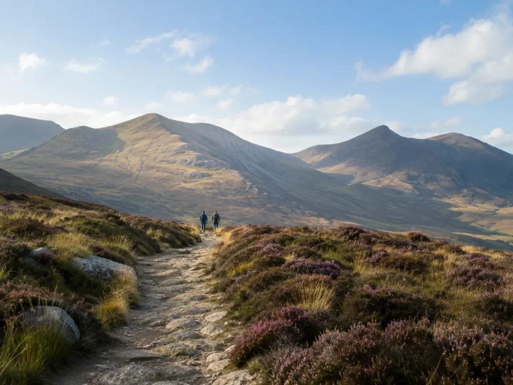
Slieve Donard
The highest point in Northern Ireland, up the Glen River and along the Mourne Wall.
Read the full route guide →Annalong Coastal Path
Flat shore path past the harbour, and the only walk you can start on foot from the house.
Read the full route guide →